Destin Dolphin Cruise (opens in a new tab)
Our product is unique because of how easy it is to walk around and see over the side of the boat. Our boat is stable open air with a…
1–2 hours
Prices checked
Water feature
Last updated
Twenty-seven miles of near-tideless brackish water with one narrow way out to the Gulf, which is why everything on this coast floats on it.
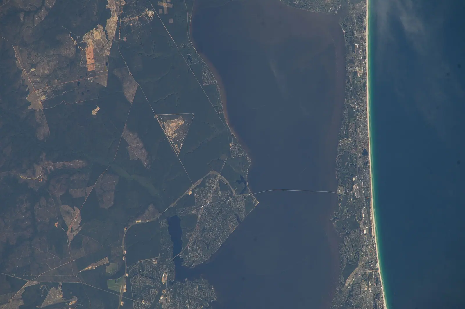
Photo: Earth Science and Remote Sensing Unit, NASA Johnson Space CenterPublic domain
Almost everything that happens on the water here happens on Choctawhatchee Bay, and almost no visitor arrives knowing its name. The Gulf gets the photographs. The bay does the work.
It is a big, shallow, oddly shaped sheet of brackish water lying behind the barrier island, about twenty-seven miles from its western bayous to the Choctawhatchee River delta in the east, up to six miles across, and roughly a hundred and twenty-nine square miles in total. The deepest holes reach somewhere around forty feet. Most of it is a great deal shallower than that.
Two facts explain everything else about it. The first is that it has exactly one connection to the Gulf of Mexico, the narrow cut at East Pass in Destin, which local fishermen opened during a flood in the late 1920s and which was finally held in place by rock jetties around 1969. The second is that the tidal range here is roughly half a foot. Not six feet, not three: half of one. Water barely moves in and out, the bay barely flushes, and the surface sits flat on most mornings the way a lake does.
That combination is why Crab Island works. A submerged sandbar in an open sea would be unusable; in a near-tideless bay with a sheltered fetch, it is a place hundreds of boats can raft up in waist-deep water. It is also why the rental pontoon business on this coast is enormous, why paddleboards outnumber surfboards, and why a family with no boating experience is handed keys at ten in the morning without anyone blinking.
The trade-offs are real. Limited flushing means the bay responds badly to heavy summer rain and to whatever comes down the river, salinity swings across its length, and the water clarity that makes the Gulf famous simply is not here. This is green-brown estuary water over seagrass and mud, and it is far more productive for it.
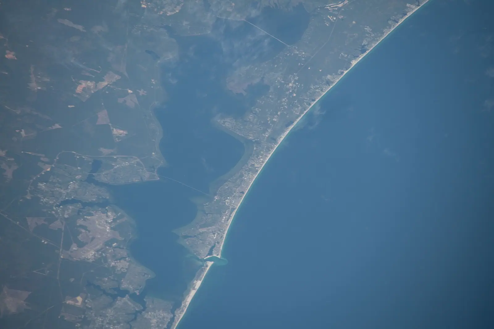
The bay lies immediately north and east of Fort Walton Beach and Destin, and you are never more than a few minutes from a piece of its shoreline anywhere in the county.
By car, the two crossings are the Mid-Bay Bridge between Niceville and Destin, which is tolled and three and a half miles long, and the long way round the western end on SR 20 and Eglin Parkway, which is free and slower. Both are worth knowing in July, when US 98 is the thing you are trying to avoid.
By boat, the free public ramp at Liza Jackson Park on Santa Rosa Sound is the usual mainland launch, with a run east under Brooks Bridge and round Okaloosa Island into the bay. Fred Gannon Rocky Bayou State Park has a ramp and a kayak launch on the north shore.
Rental pontoons and charters operate from Fort Walton Beach, Okaloosa Island, Destin harbour and Niceville. Nothing on the bay itself charges for access; the costs are the boat, the fuel and the bridge.
A tidal range of about half a foot is close to the smallest you will find on an American coast, and it changes what the water is for.
On a bay with a six-foot range, sandbars appear and vanish, currents run hard through every narrow, and a boat anchored at noon can be sitting on mud by four. None of that happens here. The sandbar you anchored on is the same depth when you leave. The current that matters is almost entirely in and around East Pass, where the bay's whole exchange with the Gulf squeezes through one gap and runs genuinely fast on a falling tide.
Wind, not tide, is the variable to plan around. With nothing to slow it across twenty-odd miles of open water, an afternoon sea breeze out of the south builds a short, sharp chop on the bay far quicker than newcomers expect, and it is a wet ride home rather than a dangerous one in a rented pontoon that was flat calm at nine.
The practical rule that locals follow without thinking: be on the water early, be off it by mid-afternoon in summer, and watch the thunderstorm line building inland over Eglin long before it reaches you.
The Choctawhatchee River enters at the eastern end after running about a hundred and forty miles from southeast Alabama, and it brings the tannic, tea-coloured water and the sediment load that make the eastern bay look nothing like the western bay.
At the other end, salt comes through East Pass. Before the pass was cut the bay was considerably fresher, and opening it changed the chemistry of the whole system permanently. Oyster beds, seagrass distribution and what you can catch where all moved in response, and the fishing communities on this coast are still arguing about the consequences a century later.
What you see as a visitor is a gradient. The western arms near Fort Walton Beach and Destin are saltier, clearer and hold more Gulf species. The eastern bay is browner, fresher and more river than sea. After a wet week the whole thing shifts west.
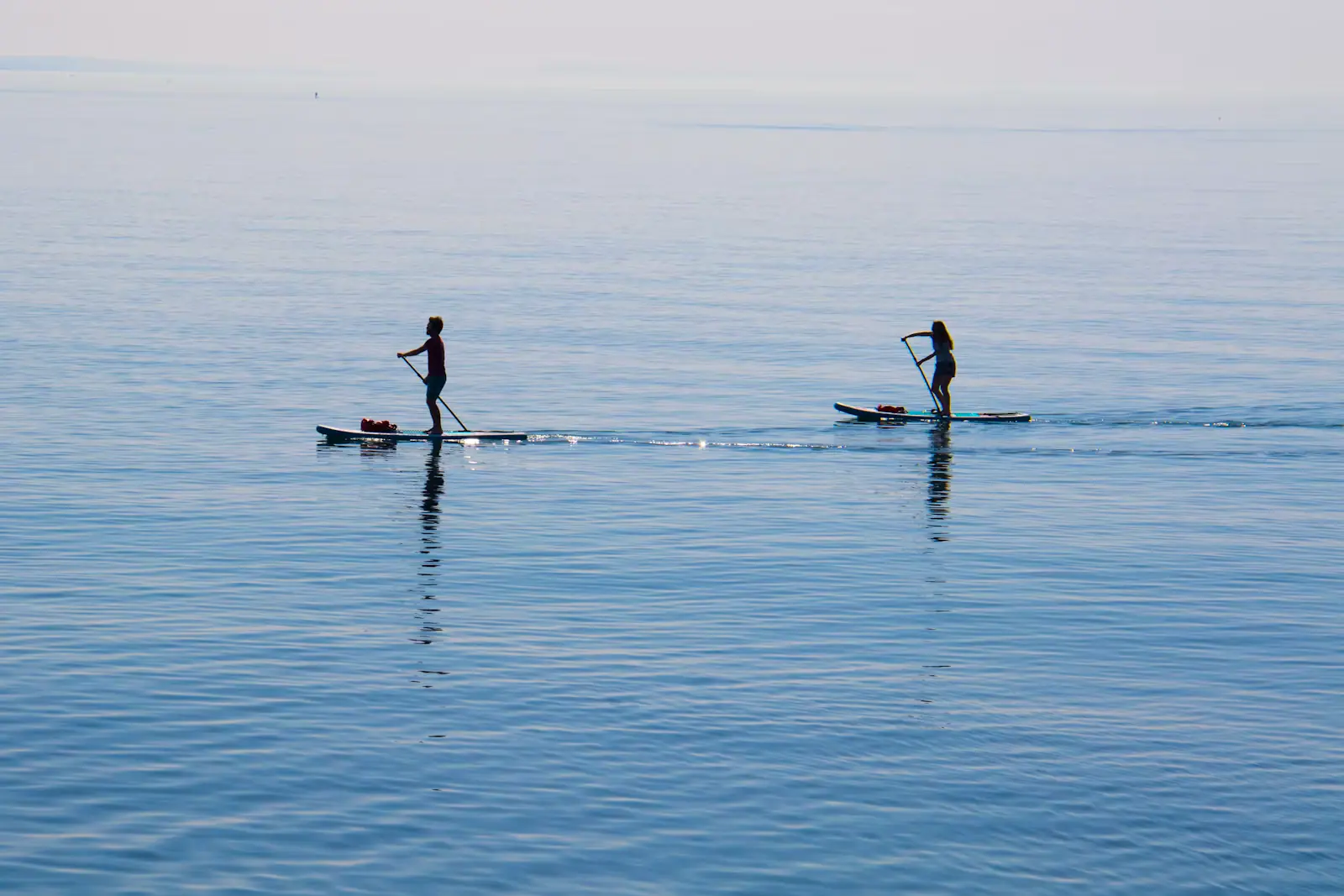
The bayous that branch off the northern shore are the interesting edges: Rocky Bayou, Boggy Bayou at Niceville, Garniers Bayou behind Shalimar, Cinco Bayou. They are sheltered, shallow, fringed with cypress and pine rather than mangrove, and they are the best paddling water in the county.
What you should not do is treat the bay as flat water all day. It is not, after about one o'clock in summer.
You do not need to own anything. Rental pontoons are the default vessel on this bay and operators run from Fort Walton Beach, Okaloosa Island, Destin harbour and Niceville. Most rentals do not require a boating licence for visitors, but Florida's boater education rules depend on your date of birth, so ask the operator rather than assuming.
If you would rather not drive a boat, the shuttle and charter market to Crab Island is large and competitive, and there are pontoon captains who will take a family out for a half day and handle the anchoring.
From the shore, the free public ramp at Liza Jackson Park puts you into Santa Rosa Sound with a straightforward run east into the bay. Fred Gannon Rocky Bayou State Park on the north shore has a ramp and a paddle launch into the quietest corner of the whole system.
The honest note about swimming from land: the bay's public shore access is limited, the bottom is soft, and the water is warm enough in August to hold bacteria after heavy rain. Health advisories are issued for specific sites rather than the whole bay; check the state's current sampling before you swim off a bank you do not know.
Operators run these trips past The Bay, or stop there as part of a longer route. We list what the booking data supports — not everything that mentions the name.
Some links below go to Viator, our booking partner. We earn a commission on bookings made through them — at no extra cost to you, and with no influence on what we recommend.

Our product is unique because of how easy it is to walk around and see over the side of the boat. Our boat is stable open air with a…
1–2 hours
Prices checked
Straight-line distances, so allow more on the road — the island is long and has one main parkway.

A submerged sandbar north of the Destin bridge where the bay runs waist-deep and several hundred boats raft up. Reachable only by water.
3–8 hoursThe sandbar itself is free public water. The cost is the boat: shuttle seats at the low end, pontoon rentals in the mid hundreds for a half or full day, private charters higher.10.3 mi away
Photograph: Nicolas Henderson

The only channel between Choctawhatchee Bay and the Gulf, started by four men with shovels in a 1929 flood and never closed since.
0.5–2 hoursFree. Viewing from the Marler Bridge walkway, Norriego Point and the east jetty costs nothing.10.6 mi away
Photograph: Jacob Weston

Thirty-odd miles of waist-deep water between the mainland and the island, with a shipping channel dredged straight down the centre of it.
1–5 hoursFree. Public access points on both shores cost nothing; equipment hire and boat fuel are separate.16.4 mi away
Photograph: Unsplash

The county's inland town, with a boardwalk over a creek clear enough to swim in and a name it chose in 1910 to stop being called Boggy.
2–5 hoursFree to visit. The Turkey Creek boardwalk costs nothing; theatre tickets and state park entry are separate.9.1 mi away
Photograph: Earth Science and Remote Sensing Unit, Lyndon B. Johnson Space Center
Where this place fits into a day, and the pages that plan one.

Start with the correction, because every visitor arrives needing it. Crab Island is not an island. There is no sand above the waterline, no shade…
Photograph: Unsplash

Look at a chart of this coast and one feature explains almost every boat trip sold on it. Between Pensacola Pass and St Andrew Bay at Panama City, a…
Photograph: Unsplash

The fishing fleet on this coast exists because of an accident of bathymetry, and the accident is worth understanding before you book anything. Off…
Photograph: Unsplash

Most destinations sell dolphin trips on the promise that dolphins live there. This one can be more precise than that, because somebody counted. In…
Photograph: Unsplash

The useful thing about paddling here is not that the water is pretty. It is that there is nearly always somewhere flat to go. Fort Walton Beach sits…
Photograph: Unsplash

US 98 is the spine, the only spine, and it crosses water three times between Pensacola and Panama City. Understanding that one fact explains almost every delay you will have here.
7 min readTamika Rowe
Photograph: Unsplash

A quarter-mile pier, a surf line, thirty miles of bay, a tidal pass and the largest charter fleet in Florida. They are five different sports and only one of them needs a big cheque.
8 min readGrant Ochoa
Photograph: Unsplash

The boat is the easy part. The parts that cost people money are the fuel policy, the licence nobody mentioned, and an ebb tide running out of East Pass against a south wind.
7 min readGrant Ochoa
Photograph: Unsplash
Roughly 129 square miles: about 27 miles from its western bayous to the Choctawhatchee River delta in the east, up to six miles across at its widest, with the deepest holes somewhere around forty feet. Most of it is far shallower than that. It is one of the larger bays on the Florida Panhandle and it sits entirely behind the barrier island, which is why visitors on the beach often never see it.
Because the tidal range is only about half a foot and the bay has a single narrow connection to the Gulf at East Pass in Destin. Water barely moves in and out, so there are no strong tidal currents across most of the bay and sandbars stay at a usable depth all day. That is exactly why Crab Island works as a place to raft up boats. Wind, not tide, is what makes the bay rough, usually from early afternoon in summer.
Yes. Crab Island is a submerged sandbar in Choctawhatchee Bay immediately north of the Destin bridge, not a piece of dry land and not in the Gulf. The water over it runs roughly one to four feet deep depending on tide and where you stand. It is reachable only by boat, which means a pontoon rental, a shuttle or a charter. The bay's minimal tide is what keeps it consistently shallow enough to stand in.
Yes, and thousands of people do it every summer weekend at Crab Island and the other sandbars. The bay is warm, sheltered and free of rip currents. Two caveats: public shore access is limited and the bottom near the banks is soft, and because the bay flushes slowly, bacteria levels can rise at specific sites after heavy rain. Florida's health department samples named beaches and issues site-specific advisories, so check current sampling rather than assuming.
The Mid-Bay Bridge, a tolled three-and-a-half-mile crossing on 141 spans between Niceville and Destin. It costs a few dollars each way for a car, less with a transponder, and in July it routinely saves an hour compared with driving round the western end of the bay and fighting US 98 through Fort Walton Beach and Destin. Rates change, so check before you travel rather than assuming an old figure.